
By Jim Rosenbarger
Conventional land use zoning is a blunt-edged tool, especially for existing, unique neighborhoods. Synonyms for “zone” include area, sector, section, belt, region or territory. These terms describe something generic, something broad. Bloomington’s neighborhoods have names: Prospect Hill, Green Acres, Hyde Park, etc. Each has varied street types, lot sizes and shapes, and house styles. Each has a unique fabric, a set of characteristic attributes.
Zoning has: R1, R2, R3, R4.
Zoning was simpler when cities sprawled across the landscape on their own. Adding density within a city’s built-out boundary adds zoning complications. Increasing density while actually improving the city requires planning tools beyond the reach of conventional zoning.
Bloomington’s administration is focused on the numbers and is still using the brute force, top-down tool of conventional zoning. Their approach is alienating residents. The re-introduced plex zoning, rejected just last year, violates our Comprehensive Plan’s specific direction to protect residential neighborhoods from the burdens of densification.
Some of the ways the city has chosen to market its zoning proposal have generated cynicism about the plan. Consider the city’s graphics. The proposed zoning amendments show a photo of an attractive, carefully maintained historic duplex to illustrate their “Use-Specific Standards for Duplexes.” The pairing gives the misleading impression that the “Standards” will ensure a beautiful result. It won’t.

If we want such a result, we’ll need a detailed form based approach calling out types of permitted materials, etc.
Form Based Zoning is not a one-size-fits-all method. Our neighborhoods’
house types, sizes, and context vary widely. This photo of a duplex shown in the City’s misleading website would be a good pattern for form based code for the Near West Side, but would be out of place in Hyde Park. To successfully develop a denser city, we need a neighborhood-specific approach.
For a city that purports to care about its historical roots, it is paradoxical that the already dense core neighborhoods (which represent approximately 5% of Bloomington’s 25-square mile footprint) are being put most at risk. Instead, these thriving neighborhoods should be recognized as models to emulate. Their success could help overcome density’s marketing problem throughout the larger areas of the city.
Bloomington’s administration has worked long and hard to promote the ability to take a pleasant walk to a coffee shop as a valued neighborhood quality. Unfortunately, the administration and its allies in the community have created an impression that this amenity is only valued when it applies to establishments in the city’s historic downtown.
The Comprehensive Plan (p. 88) calls for development of new urban village centers near existing residential neighborhoods. When dwellings and other buildings are built in close proximity, the quality of construction becomes more important.
An example in Bloomington is at the intersection of Henderson and Hillside, part of the very successful South Dunn Street development. Planning tools such as form-based zoning and transect design can help create compatible nearby village centers — when they are allowed to.
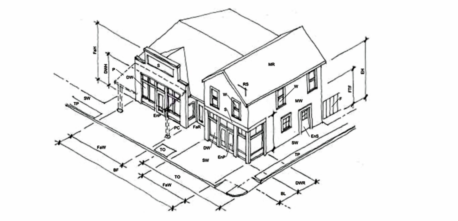
Form based zoning unsurprisingly requires drawings of buildings. The drawings become integral to the zoning requirements and can include dimensions, material notes, and details. The intent is to to create greater predictability that new buildings will complement each other and the existing context to form cohesive neighborhoods and pedestrian-oriented streetscapes. Residents, the municipality, and developers all can clearly see, with detail, what would be approved, and where it could be built.
Developers may not like the design controls and the cost of some specified building materials, but the predictability of the approval process can save them time and money. Residents benefit from up-front participation and the likelihood of a better neighborhood.
Another planning technique, the transect, creates a gradual increase of density from the single-family homes to the dense urban village center. Village centers are proposed for higher-volume roads to support small-scale retail and offices.
“The Plan for West Kirkwood” is an example of a “Sub Area Plan” and includes form-based drawings based on historic building types. The planning process involved extensive neighborhood participation, and the analysis of existing buildings and infrastructure patterns. (The Plan is available on the city’s website. Marc Cornett and I authored it.)
In 2020, when the Near West Side Conservation District (bordered on the south by West Kirkwood) drew up its Neighborhood Design Guidelines, the Guidelines Committee incorporated many of the recommendations from The Plan for West Kirkwood (p. 37 of the Design Guidelines). They recognized that even in the context of a single neighborhood, Kirkwood required exceptional considerations. In planning for an entire city, at least that much attention to detail is warranted.
If Bloomington must densify, similar plans are needed to help ensure that densification actually improves the city. The administration’s sledgehammer approach to planning, exemplified by the zoning map it presented to residents last fall, is the antithesis of form-based planning. Bloomington can and should do better.
